Sunday, 27 October 2013

More to Cumbria than the Lake District


I'm lucky to live within a half hour drive of the Lake District fells, a playground of mountains and crags for anyone keen on running, climbing, walking and even skiing.

As superb as these mountains are, they can be a little overcrowded at times; a classic 'honeypot' area that attracts over 14 million people a year to walk, bumble and eat ice cream in a National Park area of only 2,292 square kilometers. Busy.

But the Lake District National Park is just one part of Cumbria, as the maps below show
Cumbria outlined in pink, 'the north' surrounds the county...... Source: Google Maps
The Lake District National Park boundary. Source: Lake District National Park

Cumbria is also steeped in history from both a physical and human geography point of view. The 'Middleland' as Rory Stewart writes in his blog, was not England or Scotland but a separate land rich in culture and defined by its physical environment.

The Eden valley is one such example of tranquility away from the busy and popular National Park. Whilst the Lake District fells loom over the valley to the west, the more rounded, rolling mountains of the Pennines hem the valley in to the East. And they are mountains, not hills: Melmerby fell is 709 meters, whilst Cross Fell towers over the whole massif at 882 meters, its summit plateau looking like a nunatak rising above the surrounding moorland.

The geology of the Eden valley marks the area apart from the craggier Lakes crags to the west. No imposing Great End or Scafell mountains of the Borrowdale Volcanics Group with its Andesite and Rhyolite rock that is a climbers dream. Instead you have a rainbow of sedimentary rock with the occasional igneous intrusion.


The modern art look of the Eden valley and Peninne geology. Source: British Geological Society iGeology Ipad app.


Walking (or running) the Pennine massif.


We walked up from Melmerby, a small village built on the Triassic era sandstone which was put down around 242 million years ago. Most of the houses are built out of this distinctive red sandstone that defines the area. Within 2km of walking a change is noticeable in the rocks below your feet. You leave the pinky red sandstone behind and wonder across a grey gritstone that is blocky and difficult to walk through, such rock makes excellent climbing at crags such as Slipstones in north Yorkshire. Before long you find yourself rising up and across the limestone escarpment of Melmerby fell before once again stumbling over gritstone blocks in a bid to avoid the sink holes dotted across the landscape.

Sink hole below Melmerby fell.Photo: Alasdair Monteith

As the slope angle eases the Pennine plateau opens up to the east.  A rolling, endless landscape that is both enchanting and desolate, it is on the eastern side of this fell that you come across a solitary vein of igneous rock. The Great Whin Sill, an igneous intrusion of mainly dolerite rock  marks a noticeable change from the surrounding sedimentary rocks when it is exposed as a harder more resilient rock in places such as High Cup Nick and High Force waterfall. The heating from these igneous rocks 290 million years ago produced a rich variety of minerals such as lead and zinc, minerals which were mined throughout the 19th century as industrial and entrepreneurial minds recognised the wealth hidden within the hills.


Impressive crystals scattered amongst a slag heap on the eastern side of Melmerby fell. Photo: Alasdair Monteith


An adit used to access the minerals. Damp. Photo: David Monteith


So next time you travel north (or south, if you really have to ;-)) past Penrith and Tebay, look to the east at the valley and fells of Cumbria, not the Lake District.

Wednesday, 31 July 2013

Off to...... Malaysia

Next Tuesday, Lucy and I are jetting off to South Asia on a three week trip exploring Malaysia. It's a part of the world that I've never been to before so i'm pretty excited about exploring its geography and culture.

I've been checking out a few facts about the country over the last few months to get a picture of the people and country (geography geek alert). Apparently, Sarawak in Borneo has the largest cave in the world and the largest insect egg measures 1.3 cm and comes from the Malaysian stick insect. It's like Jurassic Park but without Richard Attenborough.

Until 1957 Malaysia was a British colony, history i'm hoping we can search out on our trip around the peninsula and Islands.


Malaysia! source:https://www.cia.gov/library/publications/the-world-factbook/geos/my.html


Weather wise, it looks hotter and more humid than London than this time of year, although the difference isn't as much as I was expecting.

August 1st 2013 weather from Kuala Lumpur and London. Miles apart but rain/sunshine seem to feature in both. Source: www.bbc.co.uk/weather 


To find out more about Malaysia it's worth checking out the country's profile on the CIA world factbook or comparing it with the UK through the Gapminder bubble graphs. If you were going to 'label' Malaysia you would class it as a Middle Income Country (MIC): Its population is generally quite young, it is starting to branch out into services and manufacturing but still relies a lot on exporting raw materials, whilst the GDP/per capita (a rough estimate of standard of living) and life expectency is still below the UK and other High Income Countries (HICs).

Gapminder screen grab combaring Income per person (GDP per capita) with life expectancy across the former Empire. Kenya - Low Income Country, Malaysia -Middle Income Country and the UK - High Income Country. Source: http://www.gapminder.org/


We're heading to Penang in the North East of the country first. Updates to follow.......

Friday, 28 June 2013

PTI course


Photo source: http://www.princes-foundation.org/about-us/partners-affiliates

 I spent three days this week away from Ulverston ( June average climate stats: 17°C day time high,  56 mm precipitation, 18 km/h wind speed) in sunny Cambridge ( 20°C day time avg high, 52 mm avg  precipitation, 15 km/h avg wind speed ) on the Prince's Teaching Institute geography summer school. This is the tenth year the institute has been running and I'm grateful to my school for sending me on what has been an enriching and very worthwhile course. The following is just a very brief summary of the variety of lectures, networking and discussions that took place. Hopefully it will encourage others to get involved!


50 shades of grey - fracking in the USA and UK from Prof Ian Stewart.


I was looking forward to this lecture which came only a week after Ian's BBC Horizon documentary on fracking. I found the TV documentary interesting in terms of outlining the methods involved in fracking and the various claims and accusations that have been thrown at this new and relatively unknown energy source.

Shale rock.  Photo source: Guardian.co.uk

 Ian's lecture followed a similar approach to the programme but with a greater analysis of the UK's shale gas potential and current energy mix, as well as more detail on the fracking process itself. Ian also reviewed a number of health and environmental impacts linked to fracking that have been shaking communities to the core: high methane content in tap water; fracking's connections with earthquakes; and the contamination of ground water from chemicals associated with the drilling process. It's not just those with environmental concerns who are concerned with fracking: 90% of Russia's gas exports are to Europe, a significant commitment for a country rich in natural resources. The USA on the other hand has seen a reduction in their country wide CO2 emissions due to a greater reliance on shale gas and expanding exports of coal abroad ( more embedded CO2 in coal). A point picked up in President Obama's recent announcement on bringing down America's emissions.

I did feel Ian's presentation lacked a deeper discussion on the potential impact of fracking on global warming and frackings potential to direct investment and development from renewable technology. This is particularly relevant for the UK at a time when the independent Committee on Climate Change has just reported that the UK is in danger of missing its CO2 reduction targets for 2020. However, he clearly communicated the issue in an engaging way; a key skill for scientist surely?

Christian Nold - mapping emotional change


A very different geography topic from fracking and a great example of the diversity of topics that fall under the geography topic. Christian explained his approach to mapping emotions using technology in this case a homemade emotion monitor made out of a lie detector connected to a GPS device. Individuals walk around a local place and their emotional response is recorded through the sensors on their fingers and the location recorded by the GPS. Once the data is uploaded onto a map and visualized in the form of 3D bars, Christian talks through with the individuals what each peak and trough on the graph could be, whilst trying to pull out what they remember encountering at each point. A very cool way of representing a different type of data.


Preparing to emotional map in the field. Source: Alasdair Monteith


In the field...... Geographers let loose in Cambourne.


As a group we were lucky enough to experiment with Christian's homemade emotional brew kit whilst on a field trip to Cambourne, a new build eco town that gets its fair share of media attention ( we are geographers after all...). In small groups, we walked around the town and whilst one persons 'arousal' levels were mapped by the detector, the rest of the team conducted some basic data collection - pedestrian counts, environmental quality surveys - and recorded the results as the names of each waypoint using a range of mapping apps such as field notes pro and Maverick . Once visualised, the data presents a really interesting glimpse into the emotions we go through whilst walking through places and how conventional data gathering techniques may miss this more subtle view of the world. As a group, we also came to the conclusion that a paper based emotion table and good old paper map could substitute for the flash kit and expensive GPS.

The opportunity to get out and about with fellow geographers adds weight to the need for geography to have a strong fieldwork element. You can't experience the size of a glaciated valley, see the impact of development or experience a deprived community solely through a picture or book ( no matter how much Planet Earth or Eastenders you watch).

National Curriculum focus


We also had the opportunity to discuss the new curriculum plans for KS3-5 with Alan Kinder, Chief Exec of the Geographical Association. There was a general appreciation of the increased flexibility for geography teachers and the potential for more creativity and less prescription that the proposed curriculum changes offer. However, I still remain unhappy about the exclusion of climate change as a defined topic that should be taught (  soils gets it own mention)  and the fact that the document still includes a specific list of countries that should be studied.

Summary 


One of the real strengths of the course was its ability to marry engaging, high level academic research from active researchers, with best practice in effective teaching and learning from colleagues from across the country. It often seems as though subject knowledge and the love of the topic is overlooked in CPD in favor of teaching methods. We need the balance of both. One of the reasons I came into teaching was a love of my subject, I feel most able to communicate this enthusiasm when I'm learning about new and exciting geography events and research.

Unfortunately, what we really needed in the plenary session on Wednesday was the Minister of Education to be on the podium listening and answering questions.

More information about the Prince's Teaching Institute here

Friday, 31 May 2013

Climbing, walking and running Scotland's geology

I'm very aware that when teaching about volcanoes, earthquakes or glaciation, pupils can find it difficult to comprehend the significant time scales involved. It's not surprising when you consider their previous experience of historical time scales revolves around 1066, the Roman Empire and a chap who was pretty good at turning mineral water into a particular type of alcoholic tipple 2000 years ago.


Geological holiday discoveries in your pocket.


But how to learn about geology and the vast timescales without doing a degree? Most of my geological knowledge has been acquired from books, individuals such as Dr John Stevenson during climbing and volcano related trips, and the British Geological Survey's Igeology Android and Ipad app. The app is free to download and provides you with an interactive geological map layered over an OS map at various scales down to 1:50,000. At the touch of a screen you can investigate what the bright array of coloured swirls and blobs symbolise. The terminology can be a little technical at times, but it provides you with rock type and estimated age amongst other things.

A half term week spent climbing and walking through a few prized spots in Scotland shows the diversity of rock that can be encountered and the knowledge available for those with an enquiring mind and a smartphone.


Starting old: the rocks of Dunkeld.


Our first stop on a sunny Saturday was at Dunkeld crag, or Craig a Barnes, a few miles south of Pitlochry and a very handy crag for a quick climb whilst heading north on the A9.


Craig a Barnes local geology. Image from IGeology Android app, British Geological Survey . http://www.bgs.ac.uk/igeology/


The rock was a delight to climb, although a little slippery in places and protection for the nuts and cams took a while to find at times. The Scottish rock climbs guide identified the dark grey, sparkly rock as schist but it was the age of the rocks that took me by surprise. They date from the Neoproterzoic era and are the remnants of sediments that have been compressed and heated as continents collided between 518 and 650 million years ago. Geovertical's blog post on Dunkeld has a good deal more information outlining the geology of Dunkeld and its characteristics.


Cairngorm granite


Moving further north we traveled through increasingly mountainous terrain to arrive in the arena of large whaleback mountains, glaciated valleys and volcanic rocks: the Cairngroms. We camped in Glen Feshie, a quiet wee valley on the edge of the Cairngorm massif and headed up towards Sgor Gaoith with its gentle Eastern slopes standing in contrast with the craggy, plucked and weathered West facing granite crags. The area is a super example of Scotland's volcanic history; the course and multi-coloured grain granite and rolling plateau was formed between 417-443 million years ago as continent slammed into continent during the Caledonian Orogeny.


Looking down into Loch Einich from Sgoran Dubh Mor. Glaciation for all to see! Photo: Alasdair Monteith


A snapshot of the geology of the Cairngorm plateau. Image from IGeology Android app, British Geological Survey . http://www.bgs.ac.uk/igeology/


The Cromdale Hills


Monday was a windy and unappealing day to be out on the hill, but I was keen to explore the Cromdale hills, an area I knew little about apart from in passing along the Tomintoul road. The area reminded me of the smooth slopes and depressions of the Trough of Bowland in Lancashire. The quartzite that covers the hills, a metamorphic rock, can be seen in the photo below and formed around 545-1000 million years as part of the Dalradian group of rocks. The trip was a reminder that it is not just Cairngorm granite that dominates these hills.


Quarzite block on the the summit of Sgor Gaoithe, Cromdale Hills. Useful as a windblock against 45mph winds. Photo: Alasdair Monteith
Quartzites from the Cromdale hills. Image from IGeology Android app, British Geological Survey . http://www.bgs.ac.uk/igeology/


Cummingstoun sandstone


Our last little climbing adventure took us to the sandstone cliff of Cummingstoun on the Moray coastline, an area I have been climbing at for over 15 years. The 'Costa del Moray' often provides a haven from the cold, wind and rain that regularly visits the Cairngorms and Highlands. The rock is 'generally' stable, with a variety of pockets, cracks and slopers ideal for climbing, a by product of erosion and weathering from the sea and local climate.


Cummingstoun... 2003 style. The weathered pockets in the foreground and the crack lines on the far wall provide excellent features for climbing. Photo: Rory Fraser Mackenzie.

The sandstones of Cummingston represent the youngest rocks encountered on our short journey, remnants of an ancient sand dune system that developed during the Triassic period. If you know where to look, fossils clues from the dinosaurs which roamed the ground 250 million years ago can still be found, a time when the area was more akin to a hot desert than a cool, windy Scottish coast. More recently, as the glaciers and ice caps of the last ice age melted, the coast rebounded from the weight of the ice resulting in impressive wave cut features scarring the cliffs several metres high.


The Moray coast: here be dinosaurs.... Image from IGeology Android app, British Geological Survey . http://www.bgs.ac.uk/igeology/


All in all a very enjoyable trip which highlights the range of rocks and the varied physical geography of Scotland. Having access to information on the environment around you is incredibly useful (when you can get 3G coverage, still a rarity in some parts of the UK) and something I have used when teaching and on fieldwork to demonstrate to young people the range of rocks and age of the UK. Hopefully, it encourages them to investigate and ask questions about the land and environment beneath their feet.


Monday, 8 April 2013

Are the cold spells caused by climate change? Are they becoming more frequent?

I don't know in answer to both questions.

But, this Guardian article on the fluctuating jet stream puts across some interesting ideas as to why we have experienced a number of cold winter periods over the last three years.

What I do know is that high pressure centred to the north of Britain in winter results in excellent winter climbing conditions, particularly in the Lakes (links to Paddy Cave's blog) and north Wales (links to James McHaffie's blog report).

Thanks to Dougie, Craig, Lucy and the jet stream for the climbing and banter.


The classic Raven Crag Gully IV 4 (5). Contender for best ice in the lakes? Photo: Craig Woods

Dougie starting up Chicane gully III, Devil's Kitchen. Photo: Al Monteith

Getting pumped on The Screen IV 4, Devil's Kitchen. Photo: Dougie Maudsley
Umbrellas don't just keep off the rain. Fantastic ice on South Gully, IV 5, Devils kitchen. Photo: Dougie Maudsley

Fingers crossed for warm weather and dry rock. Definitely time for cragging!

Monday, 4 February 2013

Entrepreneurial elderly or demographic transition in action?

An article in yesterday's Sunday Times caught my eye. It concerned the rise in Over 50's in employment, and made the rather confident claim that 93% of new jobs in the last decade have gone to those aged over 50. Due to the Times pay wall, I can't post the link here, but the Express seems to be running the same story on their website.

The headline seemed to imply that older people were leading the way in some form of later life entrepreneurial push. Although the article does refer briefly to an ageing population being partly responsible, it didn't explore the data in any real depth.

I've recently been exploring the UK's census data as part of the Population change topic for year 10. One of the tasks I set them was to explore the interactive sections of the official census website to compare the population pyramids for England and Wales in 2001 and 2010. They had to describe the changes in the pyramid at different age groups, and use their knowledge of development to suggest reasons for the change in the pyramids shape. Sure enough, you can see the trend in the pyramids towards a larger post 50 'baby boom' generation, and a decline in the 25-35 age group; classic Demographic Transition Model in action!

Population pyramid from the ONS

Perhaps the change in age of workers is less to do with a rise in Lord Alan Sugars and more to do with the inevitable ageing of a High Income Country.


Keeping nuclear local

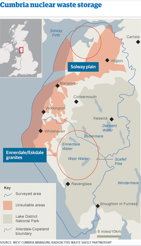
A number of local authorities in Cumbria voted on the issue of long term, deep geological storage of nuclear waste in the region last week. The BBC has a useful piece on the background to the decision, in which the County Council voted no to progressing to the next stage of investigation, but the district council voted yes (the novelty of two tier local authority control). It remains to be seen what will happen next, as the government is now left in a tricky situation with other communities  unwilling to step forward to investigate their suitability for long term storage at this stage.


I used the topic of long term storage in Cumbria with a year 11 group last year as part of the Edexcel Geography A Wasteful World topic. I managed to get hold of a paper version of the public consultation booklet that was sent out to residents in the Eden Valley. You can access similar documents and information from the West Cumbria Waste Safety Partnership website.

I got the class to work in pairs to gather information on what the initial problem was, why long term geological disposal was the only solution, and why Cumbria was the favourite to host the site. I then split the class into half to develop an open discussion based on the proposal that: ' Nuclear waste should be stored long term, underground in West Cumbria'

I also showed them the documentary film 'Into Eternity' that explores the construction of the Onkalo nuclear storage facility in Finland. There is a trailer for the film on YouTube The first of its kind in the world and an indication of could be built under the Lake District.
You could perhaps hold a vote similar to The Guardian's, using an online voting tool.


Thursday, 15 November 2012

CO2 emissions by Local Authority area. 2005-2010

I've blogged previously about the Google Motion Charts I created as part of my previous job to display Carbon Dioxide (CO2) emissions for various Local Authorities 

I've finally got round to inputting the latest DECC CO2 data for UK Local Authorities from 2005 to 2010. These data were formerly referred to as National Indicator 186, DECC have revised them so that the 5 years are comparable for the first time. You should (hopefully) be able to see the full dataset below, if not it can be accessed in a new window here. 

The X and Y data sets can be changed by clicking on the drop down boxes and individual authorities monitored by clicking on the bubbles. It's best changing the scale to Log and then click the play button. Bubble size indicates total CO2 emissions.


It's interesting to note the decrease in Industrial and Commercial emissions that takes place for the majority of authorities between 2007-2009, before stablising and then reversing back to growth in 2010.
This links in with a Google Fusion map that the Guardian Data team have produced on CO2 per capita emssions for UK Local Authorities between 2009-2010, which shows a 2.7% increase nationally.


Change in per Capita CO2 emissions for UK, 2009-2010. Source: Guardian Data blog: http://www.guardian.co.uk/news/datablog/interactive/2012/aug/24/carbon-emissions-per-capita-uk-mapped-local-authority

Looks as though we still have quite a way to go in terms of reducing emissions in industry and at home in the long term. 

Happy analysing!


Thursday, 8 November 2012

Geography....... Never boring

A hurricane tracking up the Eastern sea board, followed by a national election with global implications.


Relevant, engaging and interesting lesson topics. The Guardian's Election 2012 site is worth checking out for the data on voting, along with this Time article on the effort and focus on raising cash and spreading the campaign message.

I also used this short snippet with my geography classes this week of Obama's speech in Chicago following the announcement of his re-election. It's a great example of Obama's superb oratory combined with a great set of messages about hope and equality.


Photo source http://images.businessweek.com/cms/2012-11-01/1031_sandy_aerial_630x420.jpg

Geography is never boring!


Wednesday, 1 August 2012

An Olympic Revelation from 2003

Heather Stanning and Helen Glover's Gold medal in the Women's Pairs demonstrates what can be achieved with dedication, training and a will to win. 

But our Gordonstoun School leaving book from 2003 was well ahead of all the pundits and journalists with this prediction of Heather's future Olympic glory.

Not a bad prediction (even if the spelling was pretty poor...!)


Captain of the Hockey team and Head Girl amongst other things, it's pretty clear that great things come to those who give it their all and are supported and encouraged along the way. Quite an inspiration for the next generation!